Project Description
1868-1888
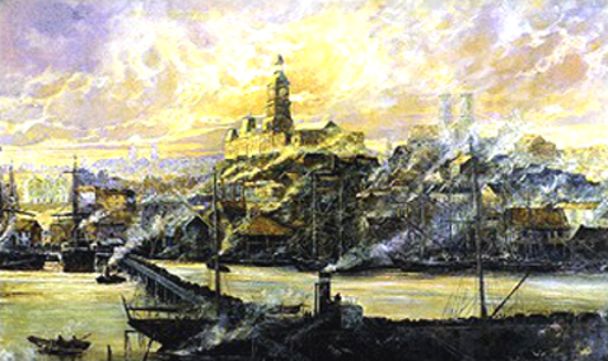
The growth of an industrialised Sydney during the period is represented by this painting of commercialised Darling Harbour, as seen from Pyrmont in the 1880s, crowded with factories and warehouses and throbbing with activity. Right in front is the bustling “Hungry Mile” – the stretch of wharfside road following the shore of the harbour.
By 1830, when Governor Darling conferred his own name to Cockle Bay, shipping had become a well-developed activity there. The area proved ideal as a commercial port and continued to develop even further. The fog and smoke that became common of the highly industrialised area, resulting from steam-powered ships and industrial machinery, gave a sombre ambience to the harbour. After the opening of the Suez Canal in November 1869, the steam-ships which had been in competition with the speedy Clipper ships for the Australian wool and wheat trade, eventuated the victors.
The most prominent structures in the painting, defining the skyline from left to right, are the Great Synagogue, the Sydney Town Hall and St Andrew’s Cathedral. Both the Town Hall and St Andrew’s in the summit of a transverse ridge that was the southern bank of the Tank Stream. It was part of a steep hill that was known as Brickfield Hill, since clay for brickmaking was obtained from its slope.
The Great Synagogue opposite Hyde Park in Elizabeth Street, was opened on 4th March, 1878. It was the second synagogue to be built in Sydney, taking over as the centre for Jewish religious services from the York Street Synagogue on completion.
As Sydney prospered and expanded, the City Council passed an Act to erect a Town Hall on the site of Sydney’s second largest cemetery, the old Burial Ground. Prince Alfred had already laid its foundation stone in 1868. Building began after the headstones and the remains of its deceased were disinterred and reburied at the Sandhills and Rookwood cemeteries. The building was constructed in sections and completed by 1889. It was initially called Centennial Hall to commemorate Sydney’s Centenary, later picking up the present name of the Sydney Town Hall. It has a lofty clock tower on its top, and a large concert auditorium containing a huge pipe organ as its principle internal feature.
St Andrew’s Cathedral, named after the patron Saint of Scotland, was an Anglican church designed in a neo-Gothic style. To the right of the Cathedral is the district known as the Haymarket, lying at the food of Brickfield Hill. It contained what was then known as the Cattle and Com Market, and now as Paddy’s Market.
To the bottom left of the painting can be seen the first Pyrmont Bridge, connecting Wharf Street (Market Street) in Darling Harbour to Union Street in Pyrmont. The bridge was made of wood and designed with a “swing panel” operated by hand gears. Foundations for a stone bridge were laid in December 899, and the new bridge opened in June 1902.
To the left are three adjoining white buildings standing on the corner of Market and George Streets. These were part of what was known as the “New Market”, where people went to shop for food and other goods. This Market Place was Eater replaced by the massive Queen Victoria Building in 1989.
Darling Harbour was the centre of the commercial expansion that changed the history of Australia, leading to extensive factory building and stimulating the import and export industries.