Project Description
1968-1988
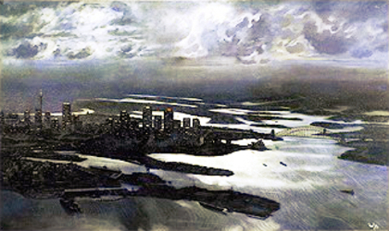
This painting depicts the Sydney city skyline as seen in the early 1980s. A bird’s eye view of the city and its surrounding geography, it is taken from above Port Jackson’s waters in the area towards Elizabeth Bay, just in front of Garden Island, looking directly west. It is fittingly an aerial shot, for the Sydneysiders of the modern age are used to admiring their beautiful harbour as seen from helicopter, aeroplane and satellite photographs.
Garden Island can be seen prominent at the centre bottom of the painting. It is names after its original use as a garden for the first settlers. The dockyard is supposedly being modernised at huge cost, but evidence indicates only an ugly stagnant sprawl of scaffolding, giant cranes and steel towers – a marked contrast to the sweeping sails of the Opera House, the majesty of the Harbour Bridge and the beauty of the rest of the harbour.
Continuing to the left of this are the inner-city suburbs of Potts Point, Elizabeth Bay, Woolloomooloo, and part of Kings Cross, Sydney’s red-light district.
Just behind and a bit to the right of the Melbourne (berthed on the opposite side of Captain Cook Dock. in Woolloomooloo Bay) can be made out the Andrew “Boy” Charlton Pool, adjoining the Royal Botanic Gardens, which makes up the dark area behind it. The Gardens extension out into the harbour, to the right. ends at Mrs. Macquarie’s Point.
Between Bennelong Point (the site of the Opera House) and Mrs Macquarie’s Point is Farm Cove, the site of the first cultivation programme in Australia.
In between Garden Island and Mrs Macquarie’s Point is Woolloomooloo Bay, known as Garden Cove to the first settlers. The controversial aircraft-carrier HMAS Melbourne can be seen berthed at her final resting place before she was sold for scrap metal, on Captain Cook Graving Dock in the bay.
The lighter grassland area to the left of the Botanic Gardens in the painting is “The Domain”. In the centre of it stands the New South Wales Art Gallery.
In the dark region to the left of the Opera House, which is another extension of the Botanic Gardens, is situated Government House and the Conservatorium of Music. The road we can see traversing vertically, from a level at the middle of this area, is part of the Cahill Expressway, constructed in 1959 to direct traffic between the North Shore and the Eastern Suburbs. This road can be seen joining the Bradfield Highway, which leads over the Harbour Bridge and joins Dawes Point to Milson’s Point, North Sydney, the suburb on the right side of the Harbour Bridge in the painting.
In the Harbour, towards the bottom right-hand corner of the painting, a small island can be seen – Fort Denison, or “Pinchgut” .
The city skyline is formed by an array of impressive skyscrapers, all towering above surrounding suburbs from the central metropolitan district of Sydney. The most obvious and characteristic landmarks are without doubt the Sydney Harbour Bridge, the Opera House and Sydney Tower, interrupting an otherwise rectilinear skyline.
Sydney Tower, found at the left of the painting, rises 325 metres above the harbour level to its multi-level Turret at the tower summit. It is the tallest building not just in Australia but in the whole Southern Hemisphere.
In the distance, behind the city skyline, sprawls the Western suburbs- the demographic heartland of Sydney. In population terms, Auburn is the central point of Sydney. They begin with the historic suburb of Balmain, which can be seen just behind Goat Island, and continue with the Parramatta River out to the foothills of the Blue Mountains.