Project Description
1808-1828
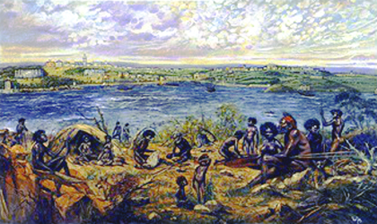
This painting depicts the early settlers’ Sydney Cove, with an aboriginal tribe living opposite it. Although the two races attempted to segregate themselves from each other initially, contact was inevitable and the settlement at Sydney Cove brought about the beginning of the end for the Aborigines’ old way of life. The natives of Sydney were nomadic hunters, food gatherers and fishermen, moving around the camp-sites of their own area according to the season and supply of food. Because they relied on natural food available in the range (territory), they had no domesticated animals – with the exception of the dingo and grew no crops. There were four or five tribes in the Sydney region.
The painting shows Sydney Cove as it would have been seen looking south from Kirribilli, and the tribe portrayed is that of the Camerra. Other tribes in the Sydney region consisted of the Cadi, the Wangal and the Wallumede.
Behind the aboriginal settlement in the painting, we see the white man’s Sydney Cove as it was in the late 1920’s, clearly the result of a very different kind of lifestyle to that of the Aborigines.
To the extreme left can be seen Fort Macquarie. one of two forts protecting Sydney at the entrances of its harbour, built at Bennelong Point as part of a defence plan against attack by sea. It is now the site of the Sydney Opera House.
The area of the right of Fort Macquarie is the Royal Botanical Gardens. In the centre of the Gardens can be seen the Government House Stables, now the Conservatorium of Music.
Further up, behind the windmill. can be seen the surgeon’s quarters of the General Hospital in Macquarie Street, known as the “Rum Hospital”. The next building along is the Hyde Park Barracks, built to be used as a lodging place for convicts in need of temporary housing on disembarkation from transports.
Towards the right can be seen what was the highest point on Sydney’s horizon, St. James’ Church, in King Street. Going along is the Supreme Court building. Just under it is the old Government House on the corner of Phillip and Bridge Streets.
The line of buildings along the shore of Sydney Cove are just in front of Bridge Street, the main link between the east and west sides of Sydney. separated by the Tank Stream.
At the extreme right of the painting we see a large hill, with a f0Tess situated at its top, used as a lookout to keep a watch down the harbour for French ships. The observatory was built for sighting the return of Halley’s Comet in 1835. It is near the present site of the Sydney Harbour Bridge’s southern pylons. Just above the observatory is Fort Phillip, a hexagonal citadel.
Situated along the western shore of Sydney Cove is the Government Shipyard of Campbell’s Wharf. The small two-storey structure to the left of it is Cadman’s Cottage. Towards the left is a very prominent, large four-storey building which was a landmark of Sydney until its demolishment in 1940; The Commissariat Store. The Maritime Services Building now stands on its site.
To the left of this can be seen a trail of shrubbery. Beside this trail runs the Tank Stream, a fresh water course that bisected the settlement and supplied all of its drinking water. The area of the river’s western side (to the right of the painting) is the Rocks. The stream runs parallel to and in between George and Pitt Streets.